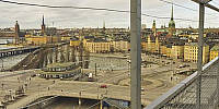

Slussen from Katarinahissen
Slussen, Stockholm, Sweden
March 21, 2009, 14:58 UTC

Loading panorama viewer ...
Configuring ...
© 2009 Lennart Mollerstrom,
Some Rights Reserved.

Caption
Slussen is Swedish and means "the lock." The lock Karl Johanslussen where boats can pass from Lake Mälaren to the Baltic Sea has given the place its name. Slussen is an ingenious traffic solution built in the 1930's and still in use today. You travel through Slussen by car, boat, bus, train, subway, on foot, on a bicycle or leave it by elevator. Slussen has a subway (underground) station, bus terminals and commuter railway station to Saltsjöbaden. By road you can enter from any of several direction and exit in any of the other directions without crossing the path of other traffic, only merge. If you are too tired to walk the sloping streets or the stairs to the heights of Södermalm you can take the elevator Katarinahissen. Read more about Slussen.
Equipment
Hardware: Pentax K20D with Pentax 10-17 mm fish-eye @10 mm, Nodal Ninja 3 MKII, Benro A-298 n6 tripod.Software: Lightroom 1.1, Hugin, GIMP, Match-n-shift/Autopano-SIFT, Enblend/Enfuse, Photoshop Elements 6, Pano2QTVR.
 Tap or click the zoom icon in the bottom right corner of the picture to switch between in-page and fullscreen view