WWP Home arrow right This Event arrow right Indices: Alphabetical | Regional | Thumbnail | Map previousPrevious | Nextnext
event title
USA
portrait Jim Cole
Highs and Lows
Multnomah Falls, Oregon, USA
mini manual

This should be a panorama image.

If you can read this, something went wrong.
We support these player technologies:

With ... you can view ...
Apple QuicktimeVR
(part of Quicktime)
all contributions
Adobe Flash Player 10.1 or newer most (not all, some contributions are QTVR-only due to historical reasons)
Javascript + HTML5 / WebGL many, but depends on photographer's choice of file upload (newer event = more likely to work) and your device's capabilities. You may experience slow playback, distorted images or unexpected browser quitting if there is only limited memory/GPU power available.
[?]
Copyright © 2009 Jim Cole, All Rights Reserved
Whole Reality
Previous panorama: Uri CoganfullscreenA-Z Regions ThumbnlsShow in MapNext panorama: William M. Delabarre

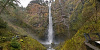
Multnomah Falls, in the Columbia River Gorge, is the second-largest year-round waterfall in the nation, dropping 620 feet. Waterfalls inherently occupy space of varying heights. In this case, addition of the lower falls, walking bridge, winding paths, and Columbia river in the distance, combine to diversify elevations. The waterfalls themselves range from tall, straight, falls, to gentle cascades. So perhaps a little diversity in diversity...

Location Map Geographic Coordinates:
Latitude: 45° 34' 38" N
Longitude: 122° 6' 58" W
arrow Show at MultiMap.com [what is MultiMap?]
arrow Show at Google Maps [what is Google Maps?]
arrow Show in Google Earth* [what is Google Earth?]
* requires Google Earth
installed on your computer

Date/Time:
March 23, 2009, 20:10 UTC (12:10 local time)

Equipment:
Nikon D300, 10.5mm fisheye, and Nodal Ninja 5.


text
WWP Home arrow right This Event arrow right Indices: Alphabetical | Regional | Thumbnail | Map previousPrevious | Nextnext