
Getting Around....
Switzer Canyon Drive & East Route 66 - Flagstaff, Arizona, USA
March 21, 2009, 20:30 UTC (13:30 local)

Loading panorama viewer ...
Configuring ...
© 2009 David Schaubert, All Rights Reserved.
Caption
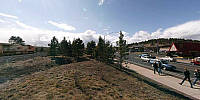
In this panorama I captured a diverse group of methods people use to get around. In this case; feet, bicycle, automobile, and train (I missed a roller-blader that went by when I was setting up).Flagstaff grew out of the railroad that enabled the Riordan Family lumber mill to ship it's Ponderosa Pine products to east-coast markets. The arrival of the iconic Route 66 in the 1920's (and subsequent decline of the railroads) kept its economic engine running. More recently it has built an extensive network of walking and bicycle trails throughout the city.
This panorama was taken from a small rise between Route 66, the paralleling walking/bicycle path, the banks of a tributary to the Rio De Flag, and the BNSF railroad tracks in east-central Flagstaff, Arizona.
As a bonus, it also captures the intersection at Route 66 and Switzer Canyon Road. It was events that occurred at this corner that served as the inspiration for Jackson Browne when he wrote the line "Standin' on the corner in Winslow Arizona" for the Eagles Hit "Takin' it Easy." The location was changed to "Winslow" in the song because it sang better than "Flagstaff." Today, as before, the corner hosts the "Dog Haus" Restaurant (the bright red roofed building) but I saw no girl (my lord) in a flat-bed Ford slow down to take a look at me (all I got was a police officer eyeballing me for standing next to the railroad tracks for 2 hours whilst waiting for a train to go by).
Location
Lat: 35° 11' 36.94" N
Long: 112° 39' 0.83" W
Elevation: 2092
Precision is: High. Pinpoints the exact spot.
Equipment
Canon XTi (400D) DSLR, Peleng 8mm Fisheye Lens, Velbon D-580 Tripod, Nodal Ninja 3 (NN3) Pano Head, Apple Macintosh MacPro 2.8 GHz Dual-Quad Xeon, PTGui Pro 8.1.2, Photoshop CS2, CubicConverter 2.2.1, CubicConnector 2.0.9
 Tap or click the zoom icon in the bottom right corner of the picture to switch between in-page and fullscreen view