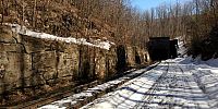

Hoosac Tunnel Beginning at the West End
North Adams, Massachusetts, USA
March 23 2008 12:50 pm

Loading panorama viewer ...
Configuring ...
© 2008 William M. Delabarre,
Some Rights Reserved.

Caption
The Hoosac tunnel was built to connect a rail line from Boston to Albany. The tunnel officially opened July 1, 1876
Location
USA-Canada / USA-Massachusetts
Lat: 42° 40' 31.88" N
Long: 74° 6' 33.05" W
Elevation: 776
Precision is: High. Pinpoints the exact spot.
Equipment
Camera- Nikon D50, Pan Head- Kaidan QuickPan IV, Stitching Software- The Panorama Factory (Smoky City Design)
 Tap or click the zoom icon in the bottom right corner of the picture to switch between in-page and fullscreen view