
The Zero Kilometer Stone
Budapest, Hungary
March 21, 2008 - 19:00 UTC (18:00 local time)

Loading panorama viewer ...
Configuring ...
© 2008 Viktor Balogh, All Rights Reserved.
Caption
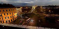
This panorama is made of two separate panoramas: one shot at daylight and one in the night. It depicts the beginning of night by showing day and night elements such as cars and pedestrians at daylight, citylights and stripes made by car headlights at night. The another reason I choose this panorama for this event: from here you can see the Zero Kilometer Stone, that is the absolute measure point for the hungarian highways. Anyway, this panorama is a real tribute to the equinox as the ratio of day and night scenes in the picture is about 50-50%.It has made at the Adam Clark square in Budapest, at the Buda side of the capital city. You can see from here the famous Chain bridge, the Zero Kilometer Stone at the park right from the roundabout, and the lower end of the Budapest Funicular, leading to the Buda Castle.
Zero Kilometer Stone is a 3 m high limestone sculpture in Budapest, forming a zero sign, and an inscription on its pedestal reading "KM" for kilometres. This statue denotes the place from which all the highways in Hungary are measured. The starting point was initially reckoned from the threshold of the Buda Royal Palace, but it was taken down to the Széchenyi Chain Bridge when it was built in 1849.
Széchenyi lánchíd or Széchenyi Chain Bridge is a suspension bridge that spans River Danube between Buda and Pest, the west and east side of Budapest, the capital of Hungary. The first bridge across the Danube in Budapest, it was designed by the English engineer William Tierney Clark in 1839, after Count István Széchenyi's initiative in the same year, with construction supervised locally by Scottish engineer Adam Clark (no relation). It opened in 1849, thus became the first bridge in the Hungarian capital. At the time, its center span of 202 m was one of the largest in the world. The pairs of lions at each of the abutments were added in 1852.
Virtual Tour in Budapest
About the Funicular
Have you questions about the method this panorama was made?
Review this panorama at http://vrphoto.hu!
About the Funicular
Have you questions about the method this panorama was made?
Review this panorama at http://vrphoto.hu!
Equipment
Canon EOS 300DTokina 12-24 F4 rectilinear lens @12mm
Manfrotto 303SPH spherical head
Hugin v0.7 beta 3 & PS CS2
Interesting anecdote about the bridge
Among the anecdotes relating to the bridge, the most popular is that the lions were sculpted without tongues and the sculptor was mocked so much that he jumped into the Danube in shame. The lions do have tongues (though not visible from below, which is the usual point of view, as the lions are laying on a stone block some three meters high), and the sculptor lived as long as in the 1890s, and the only message he sent to mocking people was "Your wife should have a tongue just as my lions have, and woe will be unto you!"
 Tap or click the zoom icon in the bottom right corner of the picture to switch between in-page and fullscreen view