
The Beginning (or is it the End?)
Malvern, Worcestershire, England, UK
March 22, 2008 - 14:14 UTC (14:14 Local Time)

Loading panorama viewer ...
Configuring ...
© 2008 Robert Bilsland, All Rights Reserved.
Caption
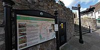
This spot marks the beginning (or the end depending on which way you look at it) of the Worcestershire way, a route passing through 31 miles of beautiful countryside. From here the way passes along the Malvern Hills, across the Teme valley, over the Abberley Hills before arriving at Bewdley, the other beginning.The original route opened in 1989 and was 8 miles longer, going from Hollybush at the southern end of the Malvern Hills to Kinver Edge just north of Kidderminster. It was after the two counties of Herefordshire and Worcestershire became self managed that in 2004 the way was re-launched at it's shorted distance with any parts that crossed into Herefordshire removed!
With each end of the way now located at more accessible places, plenty of people seem to be walking the way. It's even possible to buy a guidebook that breaks down the route into manageable chunks and points out things to see on route.
Location
Lat: 52° 6' 40.87" N
Long: 3° 20' 46.87" W
Elevation: 466 ft
Precision is: High. Pinpoints the exact spot.
Equipment
Taken on a Nikon D70 with Nikkor 10.5mm f/2.8G Fisheye lens. Mounted on a Nodal Ninja 5 Lite panoramic head atop a Manfrotto 055XPROB tripod. 6 shots taken 60° apart, tilted 15° down and a single zenith shot. Raw files then processed in Nikon CaptureNX before being stitched together using PTGUI / Smartblend and converted to a QTVR Cube using Pano2QTVR Pro.
 Tap or click the zoom icon in the bottom right corner of the picture to switch between in-page and fullscreen view