
Source of the Danube
Furtwangen, Black Forest, Germany
March 19, 2008 - 9:30 local time

Loading panorama viewer ...
Configuring ...
© 2008 Reinhard Schmolze, All Rights Reserved.
Caption
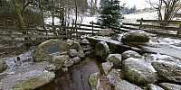
This is the source of the Breg near Furtwangen. After 49 kilometres it joins the Brigach close to Donaueschingen and from this point is called Danube. Since the Breg is the longer of the two rivers which form the Danube, it is considered its geographic source. The Danube is the second longest river in Europe and runs 2850 kilometres through Germany, Austria, Slovakia, Hungary, Croatia, Serbia, Romania, Bulgaria, Moldova, and Ukraine before it empties into the Black Sea.
Location
Lat: 48° 5' 43.08" N
Long: 8° 9' 19.26" E
Elevation: 1078
Precision is: Unknown / Undeclared.
Equipment
Pentax IST Ds, Pentax 14mm, Manfrotto SPH303, Realviz Stitcher 5.5
 Tap or click the zoom icon in the bottom right corner of the picture to switch between in-page and fullscreen view