
El Faro a Colon (The Columbus Lighthouse)
Santo Domingo, Dominican Republic
March 19th, 2008 - 01.25 PM (local time)

Loading panorama viewer ...
Configuring ...
© 2008 Nurcan Azaz, All Rights Reserved.
Caption
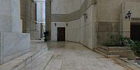
This panorama reveals the interior of El Faro a Colon (the Columbus Lighthouse). The lighthouse; a monument, cultural center, and museum; is located in Santo Domingo, Dominican Republic. Although the concept of the memorial is 140 years old, the first stones were not laid until 1986, following the design submitted in 1929 by J. L. Gleave, the winner of the worldwide contest held to choose the architect. El Faro a Colon is shaped like a large cross. In this Panorama, you see the intersection of the cross where it is argued that fragments of Columbus’s remains are resting.On the first exploration by Columbus, the ship, known as the Santa Maria, was damaged on the northwest coast of Hispaniola. Many men were left behind to establish Fort Navidad. On his second journey, Columbus brought people to establish a colony on the Island; however, Fort Navidad was found destroyed. Therefore, they established their first settlement in 1496 at the place they named Nueva Isabela on the northeast coast of the island. This settlement was destroyed by a hurricane, so Bartolomeo Columbus (the brother of Christopher) moved the settlement to the southern coast. Today the settlement still flourishes as the city of Santo Domingo in the Dominican Republic..
Santo Domingo was the first and oldest permanent European settlement in the Americas. The city is located on the Island of Hispaniola, which is today made up of the countries of Haiti and the Dominican Republic.
As Santo Domingo was a first for European explorers and colonialists, this trip was also a first for me. This trip was my first journey away from my home country of Turkey. I was elated to enjoy the people, culture, historical places, and the beaches of this wonderful country.
You can see images of the exterior of the building here. You can also see my pics and videos from Dominican Republic on my web pages.
Location
Latin America / Dominican Republic
Lat: 18° 28' 43.5" N
Long: 70° 53' 5.48" W
Elevation: 107 ft
Precision is: High. Pinpoints the exact spot.
Equipment
Photographed with my Canon A640 and Nikon FC-E9 fisheye lens, mounted on a bophoto pano bracket for Nikon FC-E9, stitched in PT-gui, QTVR file created using PanoCube.
 Tap or click the zoom icon in the bottom right corner of the picture to switch between in-page and fullscreen view