

Loading panorama viewer ...
Configuring ...
© 2008 Lennart Mollerstrom,
Some Rights Reserved.

Caption
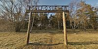
This panorama is from where Roslagsleden begins. Roslagsleden is a hiking trail that runs from Rinkeby in Danderyd to Vigelsjö in Norrtälje 124 km to the north. Roslagsleden is the last leg in Sweden of the E6 hiking trail that starts in Turkey and goes all the way to Finland
Location
Lat: 59° 24' 41.64" N
Long: 18° 1' 52.55" E
Elevation: 21 m
Precision is: High. Pinpoints the exact spot.
Equipment
Hardware: Pentax K100D with Pentax 10-17 mm fish-eye @10 mm, Self built panohead, Benro A-298 n6 tripod.Software: Lightroom 1.1, Hugin, Match-n-shift/Autopano-SIFT, Enblend/Enfuse, Photoshop Elements 6, Pano2qtvr.
 Tap or click the zoom icon in the bottom right corner of the picture to switch between in-page and fullscreen view