

Loading panorama viewer ...
Configuring ...
© 2008 Landis Bennett, All Rights Reserved.
Caption
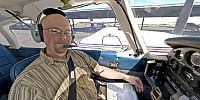
This is the beginning of a flight. It's also the beginning of a new career as a "professional" pilot.I've had my pilot's license for over a decade now and had wanted to fly since I first learned about airplanes. But in all that time I've only been able to occasionally fly due to the expense.
Here in the United States flying is relatively cheap. I can rent a single-engine, two-seat Cessna 152 for about $100 per hour, including fuel. In the UK and Europe it can be upwards of $200 per hour. But even at the "cheap" rates, flying is an extremely expensive hobby - one that I just can't afford. So in the last year or so my wife and I made a decision: I needed to find a way to get other people to pay me to fly.
That led me to a flight school where I would be trained in bigger, more complex, twin-engined aircraft like this PA-44-180 Piper Seminole. The Seminole isn't exactly a practical airplane: It cruises at about 140 knots, only takes 4 passengers and minimal baggage, and still uses about 18-20 gallons of fuel per hour. But it's an extremely good trainer and all of my potential future employers want to see that coveted "multi-engine" time in my log book. So here I am after getting my multi-engine private pilot's license and my instrument rating. Now a little more time in the Seminole and I'll be going for my commercial pilot's license and 3 different flight instructor ratings (Flight Instructor Airplane, Multi-Engine, and Instruments).
This particular Seminole may not look all that great inside, and shows its almost 30 years (it's a 1979 model), but it flies well.
The beginning of a new career. Wish me luck.
360Geographics - Panoramas from all over North America of tourist destinations and places off the beaten path.
Location
Lat: 38° 30' 57.96" N
Long: 122° 30' 51.87" W
Elevation: 24 feet
Precision is: High. Pinpoints the exact spot.
Equipment
Hardware: Nikon D200, Nikkor 10.5mm Lens, Kaidan QuickPan III SphericalSoftware: PTGui/Mac, Photoshop CS2, CubicConverter
 Tap or click the zoom icon in the bottom right corner of the picture to switch between in-page and fullscreen view