

Loading panorama viewer ...
Configuring ...
© 2008 John Riley, All Rights Reserved.
Caption
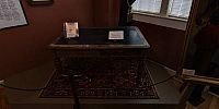
My entry to the Beginnings event of the WWP relates to the events that represent the beginning on the Civil War in the United States.The Secession Table is exhibited in the Union County Museum, located in Union, SC, USA, where I grew up. This is the table upon which the Ordinance of Secession was drawn up and signed in December 1860, whereby the State of South Carolina seceded from the United States of America. The ordinance of Secession was composed and drafted by Benjamin F. Arthur of Union. This represented the point of no return, the beginning of the events that led inevitably to Civil War in the United States, as South Carolina led the way in secession.
South Carolina Ordinance Of Secession
AN ORDINANCE to dissolve the union between the State of South Carolina and other States united with her under the compact entitled "The Constitution of the United States of America." We, the people of the State of South Carolina, in convention assembled, do declare and ordain, and it is hereby declared and ordained, That the ordinance adopted by us in convention on the twenty-third day of May, in the year of our Lord one thousand seven hundred and eighty-eight, whereby the Constitution of the United States of America was ratified, and also all acts and parts of acts of the General Assembly of this State ratifying amendments of the said Constitution, are hereby repealed; and that the union now subsisting between South Carolina and other States, under the name of the "United States of America," is hereby dissolved. Done at Charleston the twentieth day of December, in the year of our Lord one thousand eight hundred and sixty.
Visit the Union County Museum online at http://www.unioncountymuseum.com
The Governor of South Carolina at the time of secession was William Henry Gist, also of Union. In the days following the election of President Abraham Lincoln, South Carolina Gov. William H. Gist was characteristically blunt: “The only alternative left, in my judgment, is the secession of South Carolina from the Federal Union.”
Gist's plantation house is now a state park, Rose Hill Plantation State Historic Site. Their online presence is at this site
Location
USA-Canada / USA-South Carolina
Lat: 34° 42' 53.58" N
Long: 82° 38' 29.31" W
Elevation: 198
Precision is: High. Pinpoints the exact spot.
Equipment
Shot using a Nikkor 10.5mm fisheye lens and Fujifilm S2 Pro, mounted on a 360Precision Absolute panorama head. Image processing done using Adobe Photoshop CS3, with bracketed exposures combined using the enfuse algorithm as implemented in PTGui.
 Tap or click the zoom icon in the bottom right corner of the picture to switch between in-page and fullscreen view