
Loading panorama viewer ...
Configuring ...
© 2007 Romuald Vareuse, All Rights Reserved.
Caption
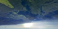
The theme "Atmosphere" is taken in it's basic meaning: a thin envelope of gas surrounding the Earth. In this panorama, Reunion Island is a symbol of the Earth itself: ocean, volcano, forests, cattle areas and human tracks: a set of elements interacting for the best and the worst. By panning down to the zenith ( ! ) you will embrace all this base of life...We are flying at 12.000 feet, 6.000 over the ground. The view shows the ocean's horizon more than 200 kilometers away. Above us, the Foret de Bébour, forming with Belouve and Plaine des Lianes the largest forest of the island. This area is part of the most recent French National Park -created this month- which extends from the volcano on the south to the borders of Le Port-town far in the north-west. The park will be a candidate for the UNESCO Natural World Heritage list in 2008.
Location
Lat: 22° 2' 0" S
Long: 55° 33' 0" E
Precision is: Medium. Nearby, but not to the last decimal.
Equipment
Canon 1ds, fisheye 15 mm and 8 mm, ptgui Mac, photoshop CS2.
 Tap or click the zoom icon in the bottom right corner of the picture to switch between in-page and fullscreen view