
Air Pollution Surveillance Station DEHE041
Frankfurt am Main, Germany
March 24, 2007 - 14:00 UTC (15:00 local time)

Loading panorama viewer ...
Configuring ...
© 2007 Jürgen Matern, All Rights Reserved.
Caption
Theme:
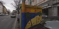
As the atmosphere itself is mostly invisible I tried to show something that affects the atmosphere and thus the air we all breathe. The panorama shows a source of air pollution (motor cars), alternatives to individual transportation by motor cars (a bike and a tram) and the surveillance station itself. The colorfull painted container is the air pollution surveillance station DEHE041.Trivia:
There are three air pollution surveillance stations in the urban area of Frankfurt/M. Two of the stations measure the background load of the air pollution. The third station which is featured in this panorama measures traffic related pollution. The station went in service on March 01, 1993.Making Of:
The shooting was done with a virtual tripod. The virtual tripod is also called a Philopod.With a fisheye attached to my camera, four pictures easily cover 360°. But due to several nearby objects I took eight shots for some more overlap. As I wanted to show different vehicles, I even took some more shots and afterwards I selected the shots with the most interesting combination of different vehicles.
I took two additional pictures for the zenith and nadir.
Links:
- My brother's WWP submission shows a similar station in Munich.
- Additional information on the surveillance stations in Frankfurt/M. (only in german)
Location
Lat: 50° 7' 28.45" N
Long: 8° 41' 30.8" E
Elevation: 123 m
Precision is: High. Pinpoints the exact spot.
Equipment
- Camera: Konica Minolta Dynax 7D
- Lens: Sigma 8mm fisheye
- Mounting: Hand held using a Philopod (without using a bubble level)
- Software: Panotools, PTGui, Smartblend, PSCS2, Pano2QTVR
- Pictures: 8 pictures @ 45°, zenith and nadir, additional images for more vehicels
 Tap or click the zoom icon in the bottom right corner of the picture to switch between in-page and fullscreen view