

Loading panorama viewer ...
Configuring ...
© 2007 Ian Kerr, All Rights Reserved.
Caption
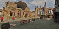
A cathedral with a 295 feet spire but no roof.On the fateful night of 14th November 1940, during a nine hour blitz, Coventry's Cathedral of St Michael was hit by incendiary bombs. The resulting fires could not be extinguished, the roof was destroyed and the ruins became a distinctive emblem for peace and reconciliation.
The following day a local vicar, Rev A P Wales, fashioned a cross with 3 of the medieval nails that had fallen from the damaged roof, this simple form was to become an iconic symbol signifying the cathedral’s endeavours to broker peaceful ends to hostilities and unite war torn countries. Some weeks later a lopsided cross of charred oak roof struts was formed and placed on an altar of rubble in the ruins at the eastern end of the Old Cathedral.
Even on a warm, sunny summer's day the ruins have a tranquillity, in which visitors talk in hushed tones and quietly contemplate the dramatic events of 1940 and other tragic conflicts. It is a place for pilgrims.
A new cathedral, adjacent to the north side of the ruins, was consecrated on 25th May 1962.
Throughout the year, important religious services move into the ruins, even on a fine day the skeleton of the 14th century building adds gravitas, there is an atmosphere. At the 11th hour on Armistice day, when November’s wet and cold elements invariably conspire to chill the veterans who gather to remember, this is a very solemn place.
In late summer, Mystery Plays; interpretations of the gospels, are performed in this vast space. As daylight fades the ruins become a unique theatre with another atmosphere. Mystery Plays 2006
 Tap or click the zoom icon in the bottom right corner of the picture to switch between in-page and fullscreen view