
Mississippi River Fog
Minneapolis, Minnesota, USA
March 24, 2007 - 02:09 UTC (8:09 local time)

Loading panorama viewer ...
Configuring ...
© 2007 Edward S. Fink, All Rights Reserved.
Caption
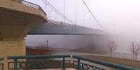
The Father Louis Hennepin Bridge disappears into the morning fog over the Mississippi River in downtown Minneapolis during the first week of spring.This was atmosphere you could practically cut with a knife; definitely the foggiest morning that I've seen in awhile.
The bridge is in First Bridge Park, and was built at the site of the first bridge in the country to span the Mississippi River.
The only building visible in the fog is the Minneapolis Post Office, which is on the site of the first permanent white dwelling west of the Mississippi River.
Equipment
Nikon D70s, Sigma 8mm, Kaidan QuickPan III, PTGui, Pano2QTVR, Photoshop.
 Tap or click the zoom icon in the bottom right corner of the picture to switch between in-page and fullscreen view