

Loading panorama viewer ...
Configuring ...
© 2007 Caroling Geary,
Some Rights Reserved.

Caption
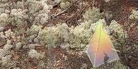
Deer moss spreads lightly over the coastal sand scrub forest floor, putting down no roots. A ground lichen, its two symbiotic parts depend on the atmosphere in different ways. The fungus part gets moisture and nutrients from air and dew. The alga part converts sunlight into food. Lichens concentrate pollutants from the atmosphere and they absorb radioactive fallout, so they indicate air quality. It is hard to identify several local species of the worldwide Reindeer moss plant family that might be in this image. One deer moss is on the Florida endangered species list. See the "Best and Biggest" link for a much larger version of this panorama, with more detail. See the "Overview of site" link for a wideangle panorama showing the forest setting for the view on this page. See the "Deer moss main page" link for Caroling's continuing focus on this plant.The panorama shows three animated geometric shapes nestled in the deer moss. Call them Unidentified Atmospheric Units (UAUs, pronounced "wow"). In 1992, I had visions of these psychic tetrahedronal chunks along the path taken by my dying son. He was flying a paraglider and fell from the air. I have not organized related experiences, nor do I have a clear explanation of the UAUs. I feel their appearance here now is an evolutionary step. See the "Animated UAUs" link for a Flash movie showing more of them moving.
About scale, this is a closeup view from less than a meter above ground, looking down around you. Each puffball would fit in the palm of your hand. Instead of lichens and pine needles, it is easy to imagine seeing an aerial view of trees and roads. Dry deer moss is often used in creating architectural models.
Supporting the deer moss are wiggly fingers of noisy colors streaming in from the lower edge of the panorama as jets of air. They serve the dual purpose of covering stitching errors.
The last link, "Guided tour movie" features a local horticulturalist explaining deer moss on a nature walk.
Best and Biggest version (15 MB): http://wholeo.net/Lookout/lookout2007/visions/panoramas/wwp3-07deerMossLivesOnAir.html
Deer moss main page: http://wholeo.net/Lookout/lookout2007/lookout07.html
Overview of site: http://wholeo.net/Lookout/lookout2007/panoramas/lookout07deerMossOverview.html
Animated UAUs: http://wholeo.net/Lookout/lookout2007/visions/movies/lookout07deerMossChunkTetsVisions.html
Guided tour movie: http://wholeo.net/Lookout/lookout2007/movies/lookout07deerMossSnookie.html
wholeo.net is a mix of the real and unreal art in Caroling's search for the whole self
Location
Lat: 30° 18' 52.3" N
Long: 87° 6' 22.3" W
Elevation: 13 feet
Precision is: High. Pinpoints the exact spot.
Equipment
Canon 300D (Digital Rebel) dSLR camera, Nodal Ninja panohead, 50 mm lens, RAW, IS0 100, 1/25 sec at f/11, focal length 50 mm, 24 exposures, -30 degree angle. Photoshop CS to edit photos. Adobe Flash 8 to add artwork. QuickTime VR Authoring Studio to make panorama. Platform: Macintosh computer, Dual 2.7 GHz Power PC G5.
Behind the scene : about the glaring highlights
I knew that the dynamic range of deer moss was hard to photograph. In all previous photos, the highlights of the airy growths were blown out. So I bracketed the exposures. Even the darkest exposures had quite light areas. I toned down the worst areas in the panorama, to provide detail. But I left some of the glaring highlights to give a sense of the glow emanating from these plants. Sometimes they seem like light sources in the darkened forest.
 Tap or click the zoom icon in the bottom right corner of the picture to switch between in-page and fullscreen view