

Loading panorama viewer ...
Configuring ...
© 2006 Tom Merchant, All Rights Reserved.
Caption
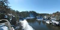
I snowshoed into this area at Interstate State Park to shoot this panoramic photograph from a bluff overlooking the Saint Croix Wild and Scenic Riverway. The Saint Croix River is the state border between Minnesota and Wisconsin.As the Ice age ended, huge glaciers melted and the water carved this deep, steep-walled gorge known as the Dalles of the St. Croix.
Interstate State Park is one of Wisconsin's oldest state parks, established in 1900.
Location
Lat: 45° 23' 55.29" N
Long: 93° 39' 59.69" W
Elevation: 815
Precision is: Unknown / Undeclared.
Equipment
Nikon D70s camera, Sigma 8mm lens, Kaidan QuickPan III rotator with spherical camera bracket and universal camera mount, and a Manfrotto carbon fiber 3444 tripod.
 Tap or click the zoom icon in the bottom right corner of the picture to switch between in-page and fullscreen view