

Loading panorama viewer ...
Configuring ...
© 2006 Thomas Rauscher, All Rights Reserved.
Caption
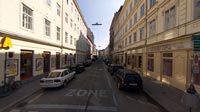
This panorama shows my home street and also a former sector border after World War II. If Austria would not have been that lucky and the allied would not have agreed to the treaty and permanent neutrality of Austria this street could have been also the place of a "Vienna Wall" similar to the Berlin Wall.To make this not only a panorama of a speculative, historic border my street is also the border between the 4th and 5th district as you can see on the streetsigns "4., Kettenbrückengasse" on the left and "5., Kettenbrückengasse" on the right. The place of the panorama is also the border for the short parking zone marked by the blue line on the ground. ;)
Equipment
Hardware: D70s, Peleng 8mm Fisheye, Benbo 2 tripodSoftware: PtGui, Pano2QTVR pro
 Tap or click the zoom icon in the bottom right corner of the picture to switch between in-page and fullscreen view