
South Table Mountain Property Juncture
Jefferson County Open Space, Colorado, USA
3/20/2006 4:35 p.m.

Loading panorama viewer ...
Configuring ...
© 2006 Shawn Steigner, All Rights Reserved.
Caption
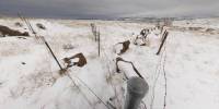
These fences represent a juncture of Federal, State, County and private property outlined by the traditional American frontier border - barbwire fence.This spot indicates a meeting of United States Department of Energy National Renewable Energy Laborartory property, a State of Colorado law enforcement training area, Jefferson County Open Space park land, and former Denver Mountain Parks land now owned by the Bradley family.
One of the last parcels of non-publicly held property on South Table Mountain, the Bradley property, was recently aquired in a land swap between the City of Denver and the Bradley family. This controversial land trade allowed Denver to aquire sensitive areas adjacent to the famous Red Rocks Park in Morrison Colorado. Unfortunately, this gave the Bradley family a key piece of South Table Mountain land that was quickly fenced off. A decades-old social trail that connected the eastern and western portions of South Table Mountain was severed in the fence building. Now, this key piece of land and its borders hinder the public's use of this obvious natural playground in the urban sprawl that is the Denver metro area.
To learn more about the effort to aquire both South and North Table Mountains for their natural beauty and public recreation use, please visit this link:
http://www.tablemountains.org
Equipment
Canon 20DSigma 8mm
Agnos Head
Panotools
PTGui
 Tap or click the zoom icon in the bottom right corner of the picture to switch between in-page and fullscreen view