
The Borderline of Trees
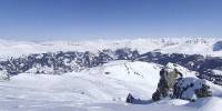
Arosa (Weisshorn), Switzerland
March 18, 2006 - 13:30 UTC (14:30 local time)

Loading panorama viewer ...
Configuring ...
© 2006 Rolf Ris, All Rights Reserved.
Caption
The borderline for trees
The tree-line or timberline ( I call it borderline ) is the edge of the habitat at which trees are capable of growing. Beyond the tree-line, they are unable to grow due to inappropriate environmental conditions. There are several types:Arctic tree-line
The furthest north in the Northern Hemisphere that trees can grow; further north, it is too cold to sustain trees.
Antarctic tree-line
The furthest south in the Southern Hemisphere that trees can grow; further south, it is too cold to sustain trees.
Alpine tree-line
The highest elevation that trees can grow on mountains; higher up, it is too cold, soil too poor, or snow cover too much of the year to sustain trees.
Exposure tree-line
On coasts and isolated mountains, the tree-line is often much lower than in corresponding altitudes inland and in larger, more complex mountain systems, because high winds reduce tree growth.
Desert tree-line
The driest places that trees can grow; drier desert areas having insufficient rainfall to sustain trees.
Wetland tree-line
The wettest ground on the margins of muskegs and bogs that trees can grow in, below which the ground is too saturated with water, excluding oxygen from the soil that tree roots need to grow. However, no such line exists for swamps, where trees, such as Bald cypress and the many mangrove species, are adapted to growing in permanently water-logged soil.
At the tree-line, tree growth is often very stunted, affected by wind, with the last trees forming low, densely matted bushes. These are known as krummholz, from the German for 'twisted wood'. The tree line, like many other natural lines (lake boundaries, for example), looks sharp from a distance, but upon sufficiently close inspection, it becomes a more gradual transition. Trees grow shorter towards the inhospitable climate until they simply stop growing.
The climate above the tree-line is called an alpine climate.
Look also at Wickipedia (All the text is from this article)
Look also at Arosa
Equipment
Nikon D70 - Nikkor 10,5 (fullframe fisheye)
Manfrotto 055ProB with PanoKing
PTMac - Photoshop - CubicConverter
Quicktime Pro
Macintosh Powerbook 17" - 1,67 GHz OSX 10.4
 Tap or click the zoom icon in the bottom right corner of the picture to switch between in-page and fullscreen view