

Loading panorama viewer ...
Configuring ...
© 2006 Richard Crowest, All Rights Reserved.
Caption
Land borders between countries are all more or less a matter of politics. Even when borders follow natural features like rivers, they do so only because someone has decided that they should. For an island nation, though, borders are a matter of simple physical geography. The sea bounds the entire country, both defining and defending its separateness and identity. Nowhere is this better expressed than in John of Gaunt's stirring speech in Shakespeare's Richard II:This precious stone set in the silver sea,
Which serves it in the office of a wall,
Or as a moat defensive to a house,
Against the envy of less happier lands,
This blessed plot, this earth, this realm, this England.
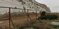
The White Cliffs of Dover are arguably the most famous part of Britain's coastal border. Immortalised in song by Dame Vera Lynn, these walls of Cretaceous chalk are an icon of southern England and a much-visited beauty spot, but as this panorama shows, they have played the role of defensive border more than once throughout history. The remains of World War II gun emplacements are just the most recent example. Look left, and the Norman keep of Dover Castle dominates the skyline. The church tower that is also visible hides a Roman pharos or lighthouse, and earlier still, ancient Britons had fortified the site with earthworks.
The chalk cliffs beneath the castle hide a warren of tunnels that were begun in the Middle Ages, with renewed activity during the Napoleonic Wars and World War II. But not since the invasion that brought the castle builders 940 years ago has a hostile power successfully crossed these waters.
In the peace that has prevailed here for the last 61 years, the sea has become more of a highway than a moat. Dover's docks last year loaded and unloaded two million lorries from the cross-channel ferries, not to mention the passenger traffic.
One thing against which neither sea nor cliffs provided any defence was the bitter east wind that blew all day under the leaden sky. Even so, plenty of walkers braved the weather to head out to the more picturesque stretches of the cliffs further to the east.
Equipment
Canon EOS 350D, Sigma 8mm fisheye lens, 360Precision tripod head.Processed with PTGui and Smartblend.
 Tap or click the zoom icon in the bottom right corner of the picture to switch between in-page and fullscreen view