

Loading panorama viewer ...
Configuring ...
© 2006 Peter Braatz, All Rights Reserved.
Caption
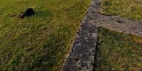
The "Monument" you can see here meandering through the landscape is called the "Westwall" (also known as "Siegfried-Line"). It was meant to be a Border between the Third Reich and the Allied troups.It is (or was) 630 km long and consisted of some 18.000 tunnels and bunkers. Built between 1938 and 1940.
More information: http://de.wikipedia.org/wiki/Westwall
(Personal note: as I had a both a HD-RAID crash and logical errors on my system I am happy to get something out at least. That weekend I did not spend as much time there as I had planned...)
More from the most western part of Germany: http://www.360pixel.de
Location
Lat: 50° 41' 48.85" N
Long: 6° 9' 26.75" E
Elevation: 0
Precision is: Unknown / Undeclared.
Equipment
Nikon D200 / Nikon 10.5 / 360precision
 Tap or click the zoom icon in the bottom right corner of the picture to switch between in-page and fullscreen view