

Loading panorama viewer ...
Configuring ...
© 2006 Lucia Bazan,
Some Rights Reserved.

Caption
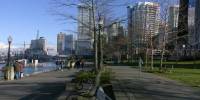
The Port of Vancouver has one of the world's finest natural deep-water harbours. It covers 247 km of coastline from Roberts Bank at the U.S. -Canada border, along the south shore of Burrard Inlet, up Indian Arm and the north shore of Burrard Inlet. Coal Harbour used to be just railway tracks not so long ago. Now with public parks, high rise condos, shops, restaurants and marinas it is one of the most expensive areas in town.
To the right is the construction of the Convention Center, the extension to the old one. It wIll be ready for the 2010 Winter Olympics.
To the left is Stanley Park. The Sea Wall goes all the way around the park, to English Bay and Falls Creek.
Location
USA-Canada / Canada-British Columbia
Lat: 49° 17' 28.43" N
Long: 124° 8' 23.44" W
Precision is: High. Pinpoints the exact spot.
Equipment
Nikon Coolpix 5400
 Tap or click the zoom icon in the bottom right corner of the picture to switch between in-page and fullscreen view