
Penobscot River Crossing-new Bridge
Waldo-Hancock (old) Bridge Gateway to Downeast Maine, USA
3/21/06.... approx 4:45 EST

Loading panorama viewer ...
Configuring ...
© 2006 Larry Cassis,
Some Rights Reserved.

Caption
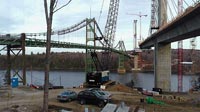
The Waldo-Hancock (county) Bridge has served as a gateway to Downeast Maine for several decades. It bridges the border between two counties but also between major geographic regions of Maine. It also bridges the border(s) between "old" and "new" for our state in many ways.The replacement for the Waldo-Hancock Bridge being built here will be the first cable-stay bridge in Maine! Designing the replacement for the Waldo-Hancock was a challenge because most cable-stay bridges tend to be very modern in their appearance. But with historic Fort Knox right next door, the local community felt very strongly that they wanted a more traditional-appearing bridge.
In a design workshop in the fall of 2003, local community members suggested that the new bridge be built incorporating a "granite" theme, in honor of the significance this stone has had on the local economy over the past two centuries. In researching historical shapes, the Maine Department of Transportation discovered that the Washington Monument was built partially of granite from Mt. Waldo. As a result, a pylon shape modeled after the Washington Monument was proposed. And as with that monument, visitors and residents will be able to take an elevator to the top of the pylon, 420 feet in the air. No other bridge in the United States offers such a possibility! The Maine Department of Transportation's goal "was" to have the new bridge open to traffic in July of 2005. For continuing updates - including a 24-hour-a-day webcam - visit www.waldohancockbridge.com.
Equipment
Nikon 990 with Kaidan 990 VR-Mount
PSCS & VRWorx Mac-PB17"
 Tap or click the zoom icon in the bottom right corner of the picture to switch between in-page and fullscreen view