

Loading panorama viewer ...
Configuring ...
© 2006 Howard Wilkinson, All Rights Reserved.
Caption
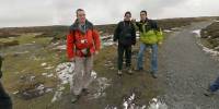
The annual outing of the Mole Valley & District Gentlemen's Ale Appreciation Society, which this year visited Ludlow, happend to coincide with the photographing of the Borders event. As well as sampling some fine locally brewed ales, the group likes to explore local scenery in the area we visit.Our walk started at Church Stretton in Shropshire and headed up onto The Long Mynd, a picturesque ridge of high ground overlooking the border between England and Wales.
Location
Lat: 52° 33' 29.99" N
Long: 3° 51' 55.03" W
Elevation: 511m
Precision is: High. Pinpoints the exact spot.
Equipment
Canon EOS 5DSigma 15mm F2.8 EX DG Fisheye
No tripod
Lots of work in Photoshop to match up the images
PTgui v5.7.1
Pano2QTVR v1.0
 Tap or click the zoom icon in the bottom right corner of the picture to switch between in-page and fullscreen view