

Loading panorama viewer ...
Configuring ...
© 2006 Chris Witzani, All Rights Reserved.
Caption
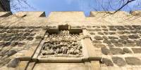
In medieval times many European cities were protected at their borders with huge walls and towers. There are only small parts of the medieval Cologne city wall left. 1881 the most of the wall around the old city was removed to gain room for the growing city. One part you can find in the south of the old city at the Sachsenring. Two round towers are on each side of this wall. There was a famous monument relief built into the wall in the year 1360. It has been restored several times. The relief symbolizes an attack in 1268. 5000 men, led by noblemen from Kleve and Limburg, broke through the wall to help the archbishop Engelbert II. who was in struggle with the citizens of Cologne. Led by Matthias Overstolz, Cologne citizens were able to defeat the intruders.
Nowadays the carnival association "Blaue Funken" resides in these walls and towers.
Equipment
Nikon D70s, Nikkor 10.5, Manfrotto 303 head, 1/125s, f/8, PanoTools
 Tap or click the zoom icon in the bottom right corner of the picture to switch between in-page and fullscreen view