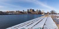

Mississippi River from Harriet Island Park
Saint Paul, Minnesota, USA
March 21, 2006 16:23 CST

Loading panorama viewer ...
Configuring ...
© 2006 Brandon Rowell, All Rights Reserved.
Location
Lat: 44° 56' 16" N
Long: 94° 6' 52" W
Elevation: 689
Precision is: High. Pinpoints the exact spot.
Equipment
Canon EOS 20D DSLR, 8mm Fisheye Lens, Manfroto 755B MDeVe Tripod w/ 303SPH Head ISO 100 @ f8, 1/400 sec., RAW
 Tap or click the zoom icon in the bottom right corner of the picture to switch between in-page and fullscreen view