

Loading panorama viewer ...
Configuring ...
© 2006 Aleksandar Janicijevic, All Rights Reserved.
Caption
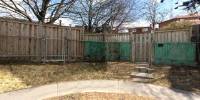
The term "border" always has negative connotations for me. It has an underlying meaning of separation. This example is a stretch of Leslie Street, one of the main Toronto arteries. It is almost three kilometers long and I am calling it "the faceless street". This panorama is stitched from 14 photos taken the same distance from the fences. It creates the illusion that you are encircled by them, and I think emphasizes the impression of separation and detachment of people from each other and prevents us from being complete human beings. It is a part of an active search and continuous observation (psychogeography) that I am conducting with the goal to expose significant successful and not so successful sides of the modern city.All over Toronto, and for that matter, in most North American cities, you can find examples like this one. It is a terrible consequence of the zoning system still in use instead of the proper urbanistic principles of city planning. It is really hard to fix problems like this one, but I think that awareness is very important in order to avoid this and similar situations. Sociability is probably the most important attribute of urban life and if we want to keep cities alive, every effort to make them joyful and meaningful and contribute to the connectivity and identity of the neighborhoods, is essential in the development of community, culture and democracy.
Urban conversations: http://una.urbansquares.com/gallery
Collection of urban squares http://www.urbansquares.com
Equipment
Camera: Nikon Coolpix 4300 with wide angle converter.
Software: QuickTimeVR Authoring Studio + Photoshop + QuickTime Pro
Granice - prevod na srpski
Pojam "granica" je za mene uvek imao pomalo negativano znacenje. Granica je imala skoro isto znacenje kao i razdvajanje. Ovaj primer je potez u Leslie ulici u Torontu jednoj od glavnih gradskih arterija. Dugacak je oko tri kilometra i ja ga oduvek zovem "ulica bez lica". Ova panorama je napravljena od 14 fotografija slikanih sa istog rastojanja od ograda. Panorama ostavlja utisak da se nalazimo u krugu bez izlaza i mislim da pojacava utisak razdvojenosti od drugih ljudi i time nas sprecava da postanemo kompletna ljudska bica. Ova panorama je deo aktivnog trazenja i neprestanog posmatranja (psychogeography) koje pokusavam da sprovedem sa ciljem da se ispolje i naznace vaznije uspesne i ne tako uspesne strane modernog grada.I u drugim delovima Toronta, a uostalom i u drugim gradovima sirom Severne Amerike, mogu se naci slicni primeri. Sve je to posledica uzasnog "zoning" sistema koji je jos uvek u upotrebi umesto istinskog urbanistickog pristupa urbanom planiranju. Jako je tesko resiti probleme kao sto je ovaj ali mislim da je vrlo vazno naglasiti stepen njegovog znacaja u cilju izbegavanja slicnih stvari u buducnosti. Drustvenost je jedan od glavnih atributa urbanog zivota i ako zelimo da odrzimo gradove u zivotu, svaki napor da se oni razviju u sredine koje imaju smisla i doprinos povezivanju susetstava i povecavanje njihovog indetiteta, je od kljucnog znacaja u razvoju drustvene, kulturne i demokratske sredine.
 Tap or click the zoom icon in the bottom right corner of the picture to switch between in-page and fullscreen view