

Loading panorama viewer ...
Configuring ...
© 2005 Sean Tamblyn, All Rights Reserved.
Caption
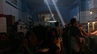
Meat vendors hawk their wares in the main market of Oaxaca, Mexico. The smell of barbecuing meat permeates the air and shafts of sunlight streak down through the haze of a dozen smouldering coal fires. Tides of people shift this way and that, and vendors whistle and call, trying to attract the attention of passerbys. It's a white balance dream: the ceiling is painted blue, illuminated by cool sunlight, while the red of the meat is accentuated by the warm glow of incandescent lights.Captured during a rare lull in the crushing crowd, the shot was immediately followed by a gaggle of Nikon shooters coming through, bright camera straps and shiny lenses glinting conspicuously in the dappled light.
The small round sausages are chorizo, and lunch next to the Coca Cola fridge will set you back about 30 pesos.
Location
Lat: 17° 4' 21.65" N
Long: 97° 44' 58.92" W
Elevation: 1730.270 m
Precision is: Unknown / Undeclared.
Equipment
Canon 20D and stock 18-55mm lens, using a Manfrotto macro focusing rail for nodal point adjustment. Distortion correction and cylindrical remapping courtesy of Kekus Lensfix and Kekus Remap Photoshop plugins. All stitching done manually in Photoshop 7 and converted to QTVR with Apple's ancient QTVR Make Panorama 2.Original photography shot at f8, 1/80 sec, 800ISO.
 Tap or click the zoom icon in the bottom right corner of the picture to switch between in-page and fullscreen view