WWP Home arrow right This Event arrow right Indices: Alphabetical | Regional | Thumbnail | Map previousPrevious | Nextnext
event title
USA
placeholder Yann Leroy
Montreal Old Port Viewed from the Top of a Cargo Boat
Montreal, Quebec, Canada
mini manual

This should be a panorama image.

If you can read this, something went wrong.
We support these player technologies:

With ... you can view ...
Apple QuicktimeVR
(part of Quicktime)
all contributions
Adobe Flash Player 10.1 or newer most (not all, some contributions are QTVR-only due to historical reasons)
Javascript + HTML5 / WebGL many, but depends on photographer's choice of file upload (newer event = more likely to work) and your device's capabilities. You may experience slow playback, distorted images or unexpected browser quitting if there is only limited memory/GPU power available.
[?]
Copyright © 2004 Yann Leroy, All Rights Reserved
www.CANDAU.com
Previous panorama: Éric LerchfullscreenA-Z Regions ThumbnlsShow in MapNext panorama: Jook Leung

This pano was taken under very cold conditions but gives an incredible and ephemeral Montreal's point of view.

It was here that the city and the port came to life more than 350 years ago.

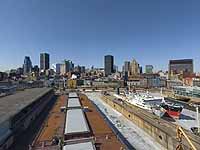
This pano was made from the highest level of a cargo boat: for the scale, just look at other large boats, cars and also at the 'bobcat loader' on the deck...

Here is the power and the magic of high quality 3D panoramas: you can always immerse yourself in this ephemeral point of view, although the boat is no more in place...

Don't forget to have a close look at this project's webpage at www.CANDAU.com/wwp04 - where you will find some special effects: sounds, flares, and so on...

Be patient while downloading the FullScreen version (2.5MB): it's worth to wait for small details such as in downtown where you will recognize some famous buildings ( 'Notre-Dame' Basilica built in 1829, the 'le1000', the Montreal Science Center, ...), and also the BioSphere (USA national pavilion for the Universal Exposition in 1967), the Cartier and Champlain bridges over St Lawrence's river, and so on ...


Location Map Geographic Coordinates:
Latitude: 45° 30' 31.7" N
Longitude: 73° 33' 14.8" W
arrow Show at MultiMap.com [what is MultiMap?]
arrow Show at Google Maps [what is Google Maps?]
arrow Show in Google Earth* [what is Google Earth?]
* requires Google Earth
installed on your computer


text
WWP Home arrow right This Event arrow right Indices: Alphabetical | Regional | Thumbnail | Map previousPrevious | Nextnext