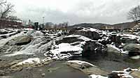

Salmon Falls Below the Potholes
Shelburne, Massachusetts, USA
17:02 UTC (12:02pm EST)

Loading panorama viewer ...
Configuring ...
© 2004 William B. Chase, All Rights Reserved.
Caption
Salmon Falls on the Deerfield River has been a destination for millenia. Once declared a place of perpetual peace between local Native American tribes for hunting and fishing, it now draws visitors from around the world. Recently declared a "NO TRESPASSING ZONE" by the Town of Shelburne for safety reasons, the Falls are still highly visible from boardwalks.
Location
USA-Canada / USA-Massachusetts
Lat: 42° 36' 9" N
Long: 73° 45' 20" W
Precision is: Unknown / Undeclared.
Equipment
Nikon Coolpix 4500 camera, Nikon FC-E8 lens, Three exposures @ 120° declination, Homemade portrait camera mount on an inverted Gitzo pano ball-head, Panoweaver 3.01 stitching software, CubicConverter 2.0.4 cubic conversion software, CubicConnector 2.0.6 node enhancement (hotspot, sound & rotation) software, Adobe Photoshop CS.
 Tap or click the zoom icon in the bottom right corner of the picture to switch between in-page and fullscreen view