

Loading panorama viewer ...
Configuring ...
© 2004 Romuald Vareuse, All Rights Reserved.
Caption
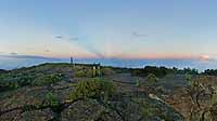
One of my favorite spot on the island, just one hour drive and 5 minutes to walk. This panorama is a sort of time-lapse. When on location, I made 5 panos between 6h and 7h am. As long as we remain in the dark, there was a beautiful phenomenon : the shadow of the mountains casts the atmosphere on the west side. So the panorama opens on this side, it is 6h20 am. All the other parts of the pano have been taken 25 minutes later, with sun. If you pan to the right, you discover a cliff and Maido Peak dominating Mafate Cirque, a natural amphitheatre 14 km long and 7 km large. No road to join this place, only walking tracks. The first village downside, Roche Plate (Flat Rock) is 1.100 m lower. Near the sun, under clouds, the top of the island, Piton des Neiges, 3.071 m height.
Equipment
Canon 1ds, fisheye full frame 15mm Canon, Manfrotto 302 head, ptmac. 8 images+top+bottom
 Tap or click the zoom icon in the bottom right corner of the picture to switch between in-page and fullscreen view