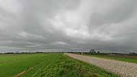

Polder Landscape with IJssel Dike
IJsseldijk Marle, Gelderland, the Netherlands
14.30 pm

Loading panorama viewer ...
Configuring ...
© 2004 Gerard Kuster,
Some Rights Reserved.

Caption
It was rainy with low clouds. Clouds of all kinds belong to the Dutch landscape. Without clouds the landscape has no depth. The river IJssel in this panorama is only a thin line on the horizon. Generally at the end of winter or after a sustained period of heavy rain the water level reaches the top of the dike, where this panorama was taken from.
Equipment
Camera: Canon EOS 10D, Lens: Sigma 8mm Fisheye, Shutter speed: 1/200, Aperture value: 9.0, ISO speed: 200, Pan Head: self made panhead mounted on a Manfrotto tripod, Software: PTMac with Photoshop
 Tap or click the zoom icon in the bottom right corner of the picture to switch between in-page and fullscreen view