

Loading panorama viewer ...
Configuring ...
© 2004 Edwin Wildeboer, All Rights Reserved.
Caption
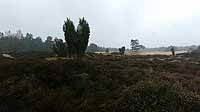
Drouwenerzand, owned by The Drents Landscape Foundation (Stichting Het Drents Landschap), is a unique piece of nature with a bizarre history. It consists of a wood, heath, juniper berry trees and driftsand of which the largest part is a grazing area for a herd of Drente heath sheep (Drentse heideschapen). This area is a last trace of a drifting sand area at the edge of the Hunzedal; behind this area you find the extensive former peat colonies.There were several attempts to restrain the drifting sand. Around 1915 this was successful, especially by planting thousands of pine trees. The afforestation was financed by the Kwartguldenvereniging. The purpose of this association was gathering money for financing moorland reclamation. Provision of work as a fight against poverty was hereby an important mainspring. Everybody who contributed a minimum of a quarter became a member. A large hill of driftsand which nowadays is closed in by the wood, is therefore still called the Quarterhill (Kwartjesberg).
Since 1974 this area is in the hands of The Drents Landscape Foundation Stichting Het Drents Landschap) which removed some of the afforestation on the heath to restore the openness of this area. Since 1981 sheep graze this area.
This area contains one of the largest populations of rare heath butterflies in the Netherlands and houses a large quantity of different kinds of birds.
The panorama was shot on a day that started dry. Later on during the shoot it was pooring with rain and there was a lot of wind which made shooting quite difficult.
Equipment
Nikon CoolPix 900s, Nikon 0.66x Wide Angle Converter WC-E24 (24mm), Manfrotto tripod with Super Pro Head, Kaidan Kiwi 900/950 panohead, Adobe Photoshop 5.5 and PanoTools 2.2.0 for dewarping, QTVR Authoring Studio 1.0.1
 Tap or click the zoom icon in the bottom right corner of the picture to switch between in-page and fullscreen view