
Providence, Rhode Island
The intersection of Francis and Gaspee Streets, Providence, Rhode Island, USA
11:49 am EST

Loading panorama viewer ...
Configuring ...
© 2004 Edward M. Huff, All Rights Reserved.
Caption
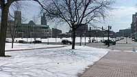
On the day of the 20th I got together with my friends Dean and Nancy and their young son Wyatt to hunt down a location that would be representative of the area in which we live. After shooting several locations I my final selection was this image of Providence taken from in front walk of the Rhode Island statehouse. The statehouse sits on a hill overlooking downtown Providence which has been going through a revitalization and is known as "America's Renaissance City". From this vantage point we can see the Providence skyline, the train station and the recently built Providence Place Mall. In the snow to the right of the walk you can see a snowman made by Wyatt as I shot the panorama. We all had a great time that first day of spring. The statehouse was designed by the New York architectural firm of McKim, Mead and White, construction of the State House began in 1895 which continued until it's completion 1901. Our statehouse is built of white native limestone. On the top of the dome stands the statue of the Independent Man, a symbol of our Rhode Island spirit.
Equipment
Nikon Coolpix 995, Kaidan Quickpan III Spherical, stitched with VRWorx and Adobe Photoshop
 Tap or click the zoom icon in the bottom right corner of the picture to switch between in-page and fullscreen view