

Loading panorama viewer ...
Configuring ...
© 2011 Miguel Sepúlveda, All Rights Reserved.
Caption
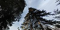
Abies pinsapo, the pinsapo or Spanish fir, is a tree species of the genus Abies, belonging to the family Pinaceae, growing to 20-30 m tall, with a conic crown, sometimes becoming irregular with age. The leaves are 1.5-2 cm long, arranged radially all round the shoots, and are strongly glaucous pale blue-green, with broad bands of whitish wax on both sides. The cones are cylindrical, 9-18 cm long, greenish-pink to purple before maturity, and smooth with the bract scales short and not exserted. When mature, they disintegrate to release the winged seeds.The pinsapo was described for science by the Swiss botanist Pierre Edmond Boissier, in his Voyage Botanique dans le Midi de l'Espagne (Travel botanical southern Spain), 1838.
The pinsapo occurs in three locations Southern Spain: Sierra de Grazalema (Cádiz), Sierra de las Nieves and Sierra Bermeja (Málaga). The largest forests occur in Sierra de Grazalema and Sierra de las Nieves. The extent of occurrence has been calculated as 940 km² and the actual area of occupancy has been calculated as being 28.7 km².
In the Sierra de Grazalema the main distribution is along the Sierra del Pinar where this variety is restricted to 4 km²; The three small localities in this area contain trees which have not yet reached reproductive age. At the Sierra de las Nieves location most trees are concentrated in the municipalities of Yunquera, Ronda and Tolox, where they occur in an area of 24 km². The smallest and most isolated subpopulation is at Reales, within the Sierra Bermeja, where it is restricted to a small area of 0.7 km².
Grows mainly on northerly exposures of the Sub-Betic mountains. The trees in the Sierra de Grazalema and Sierra de las Nieves are on dolomitic soils and have an altitudinal range of 900 to 1,600 m. Above 1,100 m they form dense, pure forests, but below this altitude they form mixed communities in dense forest with Quercus rotundifolia and Q. faginea and with a shrub layer. The forest in Sierra Bermeja is on serpentine soils and here the tree layer occurs with Quercus suber and with other conifers such as Pinus pinaster and P. halepensis.
Fire is the main threat to pinsapo forests. Other threats include pests and diseases which have increased in their occurrence over the last 15 years, possible problems derived from climate change. Threats from livestock are no longer a problem.
The pinsapo forest is protected at a regional level under the Spanish law in the "Andalusian Catalogue of Threatened Wild Plants". At the European level, have been included in the Habitats Directive (92/43/CEE). Included in IUCN Red List of Threatened Species.
Most of the pinsapo forests are included in the so-called “Network of Protected Areas in Andalusia”: Sierra de Grazalema Natural Park, Sierra de las Nieves Natural Park and Los Reales de Sierra Bermeja Nature Area.
Location
Lat: 36° 41' 21.18" N
Long: 6° 3' 21.53" W
Elevation: 1430 m.
Precision is: Unknown / Undeclared.
Equipment
Olympus Camera, ZUIKO 8mm fisheye lens, Manfrotto 303SPH Panoramic Head
 Tap or click the zoom icon in the bottom right corner of the picture to switch between in-page and fullscreen view