
RIMUTAKA FOREST PARK: KVU Hut Plateau
East of Wellington, Aotearoa/New Zealand
September 17, 2011, 11.54 am NZST

Loading panorama viewer ...
Configuring ...
© 2011 Michael Bajko,
Some Rights Reserved.

Caption
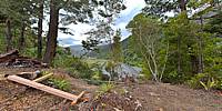
Here we've reached the Hut plateau. That's our original hut, in green, in the distance. The platform is ready for the Department Of Conservation's new hut, Turere Lodge, to take shape.For more information check out Khandallah Venturer Unit 1968 and thereabouts.
Location
Australia - New Zealand / New Zealand
Lat: 42° 21' 7.3" S
Long: 174° 59' 2.87" E
Elevation: 138 meters
Precision is: High. Pinpoints the exact spot.
Equipment
Nikon D90, Nikkor 10.5mm, panosauras, Slik tripod, PC, Windows XP Pro, Adobe Bridge, Photoshop CS5, PTGui Pro 9.1.2.
 Tap or click the zoom icon in the bottom right corner of the picture to switch between in-page and fullscreen view