

Loading panorama viewer ...
Configuring ...
© 2011 Martin Hrdlička, All Rights Reserved.
Caption
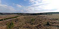
A very strong and sudden wind storm, classified as a tornado, destroyed an area of 30km of forests in June 2008.This picture shows the area after 2 years and 8 months. The new forest has already been planted but it will take many years to recover the same forest as it was before.
The catastrophe photographed a day after the tornado is documented here.
You can also see the track of the whole damage on the current Google maps.
Equipment
Nikon+Manfrotto
 Tap or click the zoom icon in the bottom right corner of the picture to switch between in-page and fullscreen view