
Irishtown Nature Park/Parc Naturel d'Irishtown
Moncton, New Brunswick, Canada
June 11, 2011, 7:42 pm

Loading panorama viewer ...
Configuring ...
© 2011 Jean Berthélémé, All Rights Reserved.
Caption
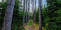
Irishtown Nature ParkThis patch of red pines (on the Blue Trail of the park) is the result of a Boy Scout project dating back to the 1940s. With the help of a local farmer, they planted the red pines as part of a forestry project to manage the area. Today, the tallest trees seen in this 360-degree image are about 80 feet (24.4 m) tall! A number of trees were damaged or killed back in 2000, during an ice storm. Park authorities are considering felling some of the dead trees as they may eventually pose a threat to hikers.
Irishtown Nature Park, in Moncton, NB, is one of the largest urban parks in Canada.
Don't leave this page until you see the image in full-screen mode!
Parc naturel d'Irishtown
Ce groupe de pins rouges (sur le sentier bleu du parc) est le résultat du travail d'un groupe de scouts dans les années 40. Avec l'aide d'un fermier de la région, ils ont planté ces arbres dans le cadre d'un projet de gestion forestière. Aujourd'hui, les plus hauts arbres qu'on voit dans cette image à 360 degrés sont d'une hauteur de 80 pieds (24.4 mètres). Une tempête de verglas, en 2000, a endommagé ou tué plusieurs arbres. Les responsables du parc, envisagent d'abattre certains arbres morts qui pourraient poser un danger pour les randonneurs.
Le Parc naturel d'Irishtown, situé à Moncton NB, est l'un des plus grands parcs en zone urbaine au Canada.
Ne quittez pas cette page avant d'avoir vu cette image en plein-écran!
Location
USA-Canada / Canada-New Brunswick
Lat: 46° 9' 43.82" N
Long: 65° 47' 41.95" W
Precision is: Medium. Nearby, but not to the last decimal.
Equipment
Nikon D300s, Sigma 8mm f/4, custom pano head, PTGui, Pano2VR, Nikon ViewNX, Photoshop.This panoramic image consists of: 5 views x 5-exposure bracketing + 1 nadir image = total of 26 images = 1 HDR image. Original images in RAW format, mastered as 16-bit TIFs, stitched into a 360 x 180 panoramic image, remapped as a cubic image to fix the nadir and add a signature, output as an equirectangular image. Master image size: 8,112 x 4,056 pixels. The image on this page was resampled to 6,500 x 3,250 pixels and saved as a JPG.
 Tap or click the zoom icon in the bottom right corner of the picture to switch between in-page and fullscreen view