
Tropical Dry Forest
Rincon de la Vieja National Park, Guanacaste, Costa Rica
December 18, 2011

Loading panorama viewer ...
Configuring ...
© 2012 Isaac Martinez,
Some Rights Reserved.

Caption
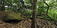
The Rincón de la Vieja Volcano National Park, in Spanish Parque Nacional Volcán Rincón de la Vieja, is a part of the Guanacaste Conservation Area and the Area de Conservación Guanacaste World Heritage Site. It is a National Park in the northwestern part of Costa Rica which encompasses the Rincón de la Vieja and Santa María volcanoes, as well as the dormant Cerro Von Seebach. The last eruption here was by Rincón de la Vieja in 1998.This panorama captured during the end of the rainy season still shows the green forest but four months later you can notice a big change in the amount of leaves and the color of the scene.
Equipment
Nodal Ninja 3 MK II, R-D8 Rotator, Nikon D300s with Nikkor 10.5mm, PTGui Pro 9.0.3, Photoshop CS5, Nikon Capture 4.
 Tap or click the zoom icon in the bottom right corner of the picture to switch between in-page and fullscreen view