

Loading panorama viewer ...
Configuring ...
© 2011 Iñaki Rezola, All Rights Reserved.
Caption
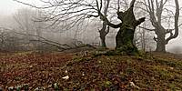
The picture of these beeches was taken at the Natural Park of Urbasa and Andia.These lands were declared a Natural Park on the 27th of February, 1997. Together they cover an area of 21,408 Ha., mainly covered with beech woods and mountain pastures. The park's location, between 42° 58' and 42° 52' north latitude, and the height of the "Sierras", ranging from the 835m. of the lowest point of the Level de Urbasa to the 1492 m. at the top of San Donato, makes it a passing place between Navarra's Mountainous Region and the so-called Mid-Region.
Variety is one of the park's natural hallmarks. The vegetation includes species belonging to the Fagus (Beech), Acer (Maple), Crataegus (Hawthorn) and Quercus (Oak) genera. Special weather conditions and the area's vegetation make for varied ecosystems within the Park, each home to a wide range of fauna.
Information from the Urbasa-Andia Natural Park.
Location
Lat: 42° 51' 32.78" N
Long: 3° 11' 29.9" W
Elevation: 897 mts
Precision is: Medium. Nearby, but not to the last decimal.
Equipment
Nikon D300, Nikkor 10.5mm, Nodal Ninja 5, Nikon Capture NX, PTGui Pro, Photoshop, Pano2VR
Hayedo en El Parque Natural de Urbasa y Andia
Esta foto fue tomada en el Parque Natural de Urbasa y Andía.Estos territorios fueron declarados Parque Natural el 27 de Febrero de 1.997. Forman una gran área de 21.408 Ha. cuya superficie está ocupada fundamentalmente por hayedos y pastos de montaña. Debido a su localización, entre los 42° 58' y 42° 52' latitud norte y la altura de las sierras, entre los 835m. de la zona más baja del raso de Urbasa y los 1492 m. de máxima altitud en San Donato, constituye una zona de transición entre la Montaña y la Zona Media de Navarra.
La variedad es una de las señas de identidad de la naturaleza del Parque. En el caso de la vegetación encontramos especies del género Fagus (hayas), Acer (Arces), Crataegus (Espinos) y Quercus (Robles). Las especiales condiciones del clima y la vegetación generan en los territorios del Parque ecosistemas variados los cuales albergan también una variada fauna.
Los hayedos ocupan la mayor parte -12.810 hectáreas-, de la superficie arbolada del Parque. La especie dominante es, por supuesto el haya, si bien ésta se encuentra en este caso acompañada por un cortejo de especies formado por arces, tilos, tejos acebos y fresnos.
El estrato arbustivo es escaso bajo el hayedo apareciendo frecuentemente en los lindes del bosque. Las especies normalmente presentes son el espino albar, el espino navarro y los rosales silvestres. En el estrato herbáceo podemos encontrar orquídeas, eléboros, narcisos y anémonas, entre otras.
Información tomada de la página oficial del Parque:
http://www.parquedeurbasa.es/
Urbasako pagadia
Argazki hau Urbasa eta Andiako Parke Naturalean hartua izan da.Lur hauek Parke Natural izendatu zituzten 1997ko otsailaren 27an. Eremu zabal hau -21.408 ha-ko azalera- gehienbat pagadia da eta mendiko larrea. Alde batetik 42° 58' eta 42° 52' arteko latitudean dagoelako eta mendien altueragatik (835 m Urbasako arrasoko tokirik apalenean eta 1.492 gorenean, (Beriainen), Nafarroako Mendialdearen eta Erdialdearen arteko trantsizio eremua da.
Aberastasuna. Horra Parkeko naturaren ezaugarrietako bat. Landarediari dagokionez, badira Fagus (pagoak), Acer (astigarrak), Crataegus (elorriak) eta Quercus (haritzak) generoetako espezieak. Klimak eta landarediak baldintza bereziak dituzte. Horrek era askotako ekosistemak sortu ditu Urbasan eta haietan ere era askotako animaliak bizi dira.
Pagadiek Parkeko azalera zuhaizturik handiena hartua dute, 12.810 hektarea guztira. Jakina, espezie nagusia pagoa da, baina tartean badira astigarrak, ezkiak, haginak, gorostiak eta lizarrak.
Zuhaixka gutxi dago pagopean, eta maiz agertzen da basoaren ertzetan. Zuhaixkarik ugarienak elorri zuria, hegoaldeko elorri zuria eta basa-arrosak dira. Belarretan orkideak, otsababak, lilipak eta anemonak aurkituko ditugu.
Informazioa parkearen webgune ofizialetik hartuta dago
http://www.parquedeurbasa.es/
 Tap or click the zoom icon in the bottom right corner of the picture to switch between in-page and fullscreen view