
Ancient Bog Oak Forest
Hillside above Loch Nafooey, County Mayo, Ireland
July 13, 2011, 15:00 (IST)

Loading panorama viewer ...
Configuring ...
© 2012 George Row, All Rights Reserved.
Caption
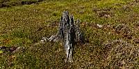
Ireland is now one of the least forested countries in Europe. Things were not always this way, Ireland was once covered in forest.Before the last Ice Age a forest stood here. As the ice sheets moved across the landscape the forest was demolished. On this hilltop, above Loch Na Fooey, the stumps of the trees have been preserved in the peat bog that now covers the area.
During a summer warm spell the water level in this small lake has retreated a little and on the dry bed the ancient forest becomes visible once more.
Prints from
Loch Na Fooey are available, from my Red Bubble Page.
Location
Lat: 53° 34' 53.17" N
Long: 10° 30' 47.02" W
Elevation: 300 metres
Precision is: Medium. Nearby, but not to the last decimal.
Equipment
Shot with a Canon EOS 5D, Zenitar 16mm fisheye f/2.8 lens. The camera was mounted on a Kaiden Kiwi panorama adapter on a Manfrotto 190XDB tripod.Horizontal photographs were taken at 60° angles and also a ground and sky shot. Each "shot" consisted of three bracketed exposures.
A total of 27 separate images were combined using Hugin in order to achieve this High Dynamic Range type result.
 Tap or click the zoom icon in the bottom right corner of the picture to switch between in-page and fullscreen view