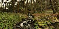

Mixed Forest and Waterfall
Pors Meillhou, Gouesnac'h, Finistere, Bretagne, France
March 27, 2011, 16:43

Loading panorama viewer ...
Configuring ...
© 2011 Dieter Kik, All Rights Reserved.
Caption
Live, forest, water, waterfall, trees, mixed forest, water cycle, springtime and oxygen.
Location
Lat: 47° 55' 52.55" N
Long: 5° 7' 42.03" W
Elevation: 24m
Precision is: Unknown / Undeclared.
Equipment
Nikon D300
Sigma 8mm f3.5
Seitz VRdrive
PTGui 9.03
Nikon Capture NX2
Pano2VR
 Tap or click the zoom icon in the bottom right corner of the picture to switch between in-page and fullscreen view