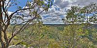

The Forest Below the Devil's Nose
Para Wirra Recreation Park, near Adelaide, Australia
September 9, 2011, 11:00 am

Loading panorama viewer ...
Configuring ...
© 2011 Chas Adlard, All Rights Reserved.
Caption
Para Wirra Recreation Park is one of the major recreation parks in the Mount Lofty Ranges of South Australia. The Devil's Nose is one of the best lookouts within the park with breathtaking views of the forest floor below.Most of the 1,409 ha park is covered with forests of eucalyptus, Long-leafed Box, Pink Gums, Blue Gums and scattered native pines, yuccas, heaths, Golden Wattles and wildflowers.
There are more than 100 species of native birds, emus, galahs, rosellas, lorikeets, fantails, thornbills and wrens. Native animals include Western Grey Kangaroos, Short-beaked Echidnas, Bearded Dragons, Sleepy Lizards and Striped Skink Lizards.
Para Wirra was the site of a thriving gold mining community over a hundred years ago and many historic relics of that time remain, including mineshafts, tunnels, equipment and ruins. In March 1898, 1,500 tons of ore had been stockpiled, but the first crush was an economic disaster and operations ceased in 1898.
Location
Australia - New Zealand / Australia
Lat: 35° 41' 54" S
Long: 138° 48' 54" E
Precision is: Medium. Nearby, but not to the last decimal.
Equipment
Nikon D80, Manfrotto tripod, Nodal Ninja panohead
 Tap or click the zoom icon in the bottom right corner of the picture to switch between in-page and fullscreen view