
Nonnemattweiher — A Lake from the last Glacial Era
Kleines Wiesental, Black Forest, Germany
June 20, 2011, 18:58 CEST

Loading panorama viewer ...
Configuring ...
© 2011 Carsten T. Rees, All Rights Reserved.
Caption
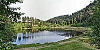
The "Nonnenmattweiher" is a small corrie lake. Its bed was formed by a glacier during the last ice age that ended approximately 10,000 years ago. In Medieval times the lake silted up and became a moor. In 1758 a dam was built to hold back the water and run a mill that was located further down the valley. Then something very special happened. The flooded moor floated up and formed a swimming peat island. On March 1, 1920, after prolonged heavy rains, the dam broke and the flood devastated most of the upper part of the adjoining "Kleines Wiesental" valley. In June, 1934, a new dam was officially opened (or closed rather) and the moor once again floated up and an even larger swimming peat island formed itself.The lake is divided into two parts by a barrier of swimming logs. In the panorama you can see the part to the left which is open for swimmers while the part to the right is under strict nature conservancy. The flat area to the very right is the swimming peat island.
The name of the lake consists of three parts: "Nonnen" or "Nunnen" is an ancient local word for cows; "Matte" is a term for a mountain meadow and "Weiher" is the German term for a pond or little lake.
But "Nonne" is also a word for a nun and there is an old lore explaining the name of this place accordingly: It is said that there was an old monastery on that very location which, after God's judgement, was drowned in the lake together with all its inhabiting nuns.
Location
Lat: 47° 47' 43" N
Long: 7° 47' 52" E
Elevation: 929 m
Precision is: High. Pinpoints the exact spot.
Equipment
Canon EOS 5D, Canon 15mm, Nodal Ninja R1, PTGui Pro, Photoshop, Pano2VR
 Tap or click the zoom icon in the bottom right corner of the picture to switch between in-page and fullscreen view