

Loading panorama viewer ...
Configuring ...
© 2011 Borut Bencak, All Rights Reserved.
Caption
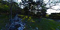
Baska. Island Krk.
Island is connected with land with bridge Titov most (Tito's bridge)
The forest (rare because of strong wind and hard stony land, hills) is above the town Baška - summer resort - seaside resort
Through the forest you may see some buildings of Baska and sea.
Equipment
Nikon D60, tripod, panohead, Nikkor 10.5mm. (This day the D60 died (one hour later) at cca 28,000 shots)
 Tap or click the zoom icon in the bottom right corner of the picture to switch between in-page and fullscreen view