
Descending into the Grand Canyon
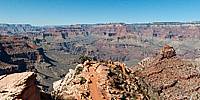
South Kaibab Trail, Grand Canyon, Arizona, USA
October 20, 2011, 12:55 pm (local time)

Loading panorama viewer ...
Configuring ...
© 2011 Ralph Greene, All Rights Reserved.
Caption
At 277 miles long, 18 miles wide and over 6,000 feet deep, The Grand Canyon is considered one of the Wonders of the Natural World. It was formed by the water of the Colorado River and its tributaries, exposing nearly two billion years of the Earth’s geology.This panorama was taken about 1,650 ft below the South Rim of the Grand Canyon on the South Kaibab Trail. In the distance you can see the Cedar Ridge and O'Neill Butte.
Location
Lat: 36° 3' 46.54" N
Long: 113° 6' 19.76" W
Elevation: 5,564' above sea level
Precision is: Unknown / Undeclared.
Equipment
Nikon D300, Nikkor 10.5mm lens. 360 Precision Atome head, PTGui Pro, Photoshop CS 5.5.
 Tap or click the zoom icon in the bottom right corner of the picture to switch between in-page and fullscreen view