
Cocathedrale Saint-Antoine de Padoue
Longueuil, Quebec, Canada
July 6, 2011, 15:30 EST

Loading panorama viewer ...
Configuring ...
© 2011 Francis Fougere, All Rights Reserved.
Caption
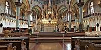
The Co-Cathedral of Saint-Antoine-de-Padoue de Longueuil
HistoryThe Co-Cathedral of Saint-Antoine-de-Padoue de Longueuil was constructed from 1884 to 1887. It is the third church in the history of Longueuil, the first being completed in 1811.
Saint-Antoine-de-Padoue became known as a co-cathedral in 1982 when the Roman Catholic Diocese of Saint-Jean-de-Québec became the Roman Catholic Diocese of Saint-Jean-Longueuil. The Cathédrale Saint-Jean-l'Évangéliste was the seat of the former diocese and was built in 1933.
Saint-Antoine-de-Padoue is part of the Saint-Antoine-de-Longueuil parish, founded in 1698, and one of the first parishes in Canada.
Architecture
The cathedral was constructed in the Gothic revival style of architecture, while the dome is an example of Byzantine Revival architecture.
The architects Maurice Perrault and Albert Menard wanted the cathedral to be of great volume. The same architects built the church's altar, combining fine stones with the hardest stone. The church was constructed at a cost of $98,895 by Eugène Fournier dit Préfontaine, an entrepreneur, farmer and carpenter.
The cathedral is very large, measuring 74 metres (243 ft) long, 41 metres (135 ft) wide and 81 metres (266 ft) high. Louis Jobin renovated the church in 1930. The roof, which had been covered in steel, was restored in 1999 using 60,000 pounds (27,000 kg) of copper.
Location
Lat: 45° 32' 24.77" N
Long: 74° 31' 28.09" W
Elevation: 46 feet
Precision is: High. Pinpoints the exact spot.
Equipment
A Canon EOS 5D with a Canon 16-35mm L-series lens set at 16mm was used on a Manfrotto 303SPH head. The spherical panorama was stitched together with PTGui Pro. This panorama was shot with available light at 4 seconds @ f11 in RAW mode with an ISO of 100 on the Canon EOS 5D. I processed all of the images in the RAW conversion software Capture 1 Pro 6.3.2.
 Tap or click the zoom icon in the bottom right corner of the picture to switch between in-page and fullscreen view