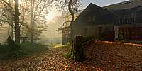

Waldsteinhaus im Herbst und Nebel
Waldstein, Fichtelgebirge, Bayern, Germany
March 11, 2011, 13:02

Loading panorama viewer ...
Configuring ...
© 2011 Dieter Kik, All Rights Reserved.
Caption
The Großer Waldstein is part of the Waldstein range in the Fichtelgebirge Mountains of Germany. It is known primarily for its rock formations caused by so-called 'woolsack' weathering (Wollsackverwitterung), its ruined castles and the only remaining bear trap (Bärenfang) in the region.The River Saale rises at the foot of the Großer Waldstein at Zell im Fichtelgebirge. The Großer Waldstein (877 m above sea level) is a mountain in the northern part of the Fichtelgebirge 'horseshoe'. Its summit area is covered by mixed forest with old stands of beech and huge rock piles, and the whole area is a designated nature reserve (20.2 hectares (50 acres)). Marked hiking trails lead from all points of the compass to the mountain, and public roads run from Weißenstadt or Sparneck to the area of the summit. At the top is a lodging house owned by the Fichtelgebirge Club, the Waldsteinhaus, from which there is an interesting walk around the summit area.
Have a look at the Waldstein House Inn for more information.
Equipment
Nikon D300
Sigma 8mm f/3.5
Seitz VRdrive
PTGui
Pano2VR
 Tap or click the zoom icon in the bottom right corner of the picture to switch between in-page and fullscreen view