
HAMing on the Border
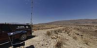
Wilderness Campsite Talley-2, Big Bend National Park, Texas, USA
May 28, 2011, 20:28 UTC (11:28 local)

Loading panorama viewer ...
Configuring ...
© 2011 David Schaubert, All Rights Reserved.
Caption
In May-July 2011, I spent 6 weeks following a 10,032 mile path through 13 Western States transmitting from rare locations on 6m (50Mhz) Amateur Radio. This pano was taken in the wilderness portion of Big Bend National Park in Southwest Texas and is in one of the rarest of the 488 Continental United States Maidenhead grids as only a sliver of it is actually in the United States.
This location is accessed by traversing approximately 40 miles of desert dirt road and is less than a mile from the USA/Mexico border on the Rio Grande River. I spent 4 days there operating on 6 meters using WSJT software and the meteor scatter digital mode FSK441 (bouncing signals off of meteorites entering the atmosphere). The average daytime temperature was 126 degrees F with a balmy nighttime low of 95 degrees.
The green strip (South) marks the path of the Rio Grande River.
More pics and my trip itinerary can be found at www.6t6kix.com
Location
Lat: 28° 59' 41.07" N
Long: 104° 12' 14.79" W
Elevation: 623
Precision is: High. Pinpoints the exact spot.
Equipment
Canon XTi (400D) DSLR, Sigma 8mm f3.5 fisheye lens, Velbon D-580 Tripod, Nodal Ninja 3 (NN3) Pano Head, Apple MacPro Dual/Quad 2.8GHz XEON, PTGui Pro 9.1.2, Photoshop CS5 Extended, CubicConverter 2.2.1
 Tap or click the zoom icon in the bottom right corner of the picture to switch between in-page and fullscreen view